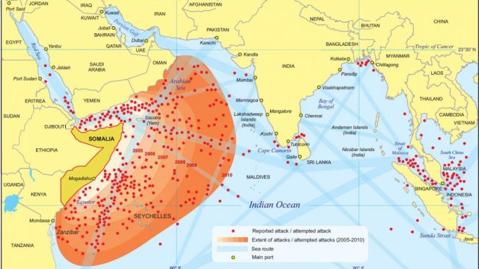
Piracy in the Indian Ocean

High risk area reduced

Extension of the area of ​​operations of Somali pirates between 2005 and 2010.

Seven years after Somali pirates managed to capture the last ship that allowed them to collect a ransom, the threat of piracy in the region has not been eliminated, as confirmed by the incidents that occur, although increasingly sporadic. It has therefore been possible to successfully reduce the area in which pirates operate and the severity of the threat, despite which we are far from reaching the moment when the guard can be lowered.

The UKMTO (United Kingdom Marine Trade Operations) office began operating at the end of 2001 in Dubai as part of the British response to the September 11 attacks of that same year against the United States. Its fundamental objective was to become a point of contact with the maritime industry and provide information on security aspects of the Middle East region.

Since April 2007, its activity has focused on maritime piracy and it is currently the organization to which ship captains report, in the first place, that they are suffering a pirate attack. It also serves as a link between the industry and the military forces present to fight Somali piracy.

We bring it up in this article because it also develops a program (Voluntary Reporting Scheme) whereby ships of any flag or owner are invited to send daily reports, preferably by email, on their position, course, speed and expected date of arrival. to your next port. Likewise, the initial report sent to UKMTO must contain, among other information, the name, type and number of the ship, name of the company that operates it, freeboard, cargo carried, flag under which it sails, nationality of the captain and the crew, Inmarsat telephone number, whether it has a private security team on board, etc. With all this information, the situation of the ships is tracked and sent to the barracks of the military personnel deployed in the area.

UKMTO advises ships that this information be provided once the ship enters the region considered at risk, called the Voluntary Reporting Area (marked as VRA in Figure 1). This risk zone was established by UKMTO in November 2002 within the following limits: for ships coming from the North, it was recommended to report their position when crossing the Suez Canal or the 23rd parallel North; for ships arriving to the area from the East, once they cross the 78º East meridian and for ships coming from the South, when they cross the 10º South parallel.

Similarly, once the ship leaves the VRA or arrives in port, a final report must be submitted to UKMTO. It is also advisable that they report any irregular or suspicious activity that they witness so that said body can issue the appropriate alerts to all ships sailing in the area. This mechanism remains operational and was very useful throughout the period in which Somali piracy was particularly active, that is, between 2008 and 2012.

For its part, the field of insurance companies establishes its own risk area in the region through the so-called Joint War Committee (JWC) of the British Insurance Market Association, known like Lloyd's. Ships entering this area must notify their insurers, who will apply the corresponding additional premiums for sailing in the region. As can be seen in figure 1, the war zone set by the JWC differs in part from that established by UKMTO.

It goes without saying that other products have been added to this type of “mandatory” insurance in recent years, such as Kidnap and Ransom or K&R policies, which cover all contingencies related to the kidnapping of a crew: compensation of the negotiator, of the translators, payment of the ransom, etc.

Boundaries of high risk areas (HRA) established in 2015 and 2019, as well as the UKMTO Voluntary Reporting Area (VRA) and Lloyd's Joint War Committee (JWC).

However, on December 1, 2015, a reduction in the area considered high risk (High Risk Area or HRA) was decided. Its limits were in the case of the Red Sea at latitude 15º North, in the Gulf of Oman at latitude 22º North, in the East at longitude 065º East, and in the South at latitude 5º South. These limits indicated as HRA (Dec.2015) in figure 1 can be verified.

Why was this decision made? Because in the previous two years, attacks attributable to Somali pirates had been very few. In 2014 only 11 incidents and in 2015 none. Furthermore, pirates had shown themselves incapable of hijacking a ship that would allow them to collect a ransom since May 2012. Almost all of the assaults recorded in previous years had occurred in the Gulfs of Aden and Oman, and in the Red Sea. Unlike what happened years ago, pirates no longer ventured hundreds of miles out to sea. The cost of deploying an operation so far from the coast is very high. And the chances of hijacking a ship were slim, due to the increasing presence of armed guards on almost all merchant ships sailing through the area. Therefore, if we were to rely solely on reported attacks, the reality is that the high-risk area could have been reduced even further.

There are other factors that explained this reduction in the risk area. In particular, economic reasons. Navigating through high-risk areas entails, as we have already noted, the payment of significantly higher insurance premiums. Hence, the Indian flag merchants benefited the most from the decision taken in 2015, given that the high-risk area was significantly moved away from the coast of their country.

In reality, India and other countries had been demanding since 2012 the reduction of the risk area given the extra cost that it represented for their merchant fleet. Another cause of concern for New Delhi was the presence in its maritime domain of armed guards to protect ships. In fact, in March 2012, Italian marines embarked on the oil tanker Enrica Lexie caused the death of two fishermen who were mistaken for pirates in international waters near the Indian coast. For the Indian government, the extension of the risk area to its waters was at the origin of this incident, which clouded relations between Rome and New Delhi. In June 2015, India raised its proposal again. And this time it was accepted, since there were no objective reasons to refuse.

Again, as of May 1, 2019, it has been decided to further reduce the high risk area. The decision has been made by a series of organizations in the shipping and oil industry: BIMCO, which brings together shipowners, operators and partners with interests in the shipping industry; the International Chamber of Shipping, which brings together representatives of more than 75% of the world's merchant fleet; INTERCARGO and INTERTANKO (representing, respectively, the interests of shipowners and operators of dry cargo vessels and tankers) and the Oil Companies International Maritime Forum (OCIMF).

In the joint statement issued by these organizations, it is stated that the reduction of the high-risk area is based on the recent experience of the shipping industry, as well as on the intention and capacity of the pirates to be able to carry out their actions and is put into practice after extensive consultation with the nations involved, with UKMTO and with deployed military naval forces and coalitions, including the Combined Maritime Forces and EUNAVFOR (European Union Operation Atalanta).

As can be seen, the new coordinates limit to the north with latitude 15º North in the Red Sea. And it crosses the Indian Ocean through a line that links from latitude 5º South to Omani waters and that, basically, consists of including the entire area that is within 500 miles of the Somali coast.

The main reason for this reduction in the high-risk area is, again, the virtual absence of incidents involving Somali pirates. In 2018, only three attacks were recorded. One in March in the Gulf of Aden and two others off the Somali coast: one in February about 160 miles from the shore and another in October, about 280 miles offshore. In all three incidents, the pirates fired at the merchant vessels (two oil tankers and a cargo ship) and in all cases the private security guards on board returned fire and made the pirates abort their attempts.

Location of some pirate attacks since 2013 and limits of both the new and the old high-risk area.

In recent years, one of the most worrying incidents was the one carried out in October 2016 by the CPO Korea tanker ship about 300 miles off the Somali coast when six people began to chase the merchant ship from a boat. When the skiff was about 400 meters from the ship, the onboard security team fired warning shots. The people who were on the boat returned fire and tried to board the ship, but failed in their attempt. They subsequently fled the area. This incident was known because it was reported 13 days later by a person responsible for the Atalanta operation. It was the first attack carried out by Somali pirates against a merchant ship in two and a half years.

(Keep reading…) Dear reader, this article is exclusively for paying users. If you want access to the full text, you can subscribe to Ejércitos Magazine taking advantage of our offer for new subscribers through the following link.